ST. PETERSBURG, Fla — 9:45 am Saturday (Meteorologist Natalie Ferrari)
All counties across the Tampa Bay area are cleared of the Severe Thunderstorm Watch. Our severe weather threat diminishes.
8:40 am Saturday (Meteorologist Natalie Ferrari)
A severe thunderstorm watch for Hillsborough County, Manatee County, and Sarasota County has been canceled.
7:15 am Saturday (Meteorologist Grant Gilmore)
The line of storms will continue to clear out this morning and the Severe Thunderstorm Watch will continue to be trimmed as the threat moves east of Tampa Bay. Skies will gradually clear and sunshine will take over for the majority of the morning. The winds will be a little breezy, especially through the afternoon. Be careful if heading out to the beach today. There is a high rip current risk due to the breezy conditions and rough surf.
7:00 am Saturday
A severe thunderstorm watch for Hernando County, Pinellas County, and Pasco County has been canceled.
5:30 am Saturday (Meteorologist Grant Gilmore)
A line of severe storms rolled through Tampa Bay early Saturday morning. This line was associated with a cold front that will be sweeping through the entire state this morning. Once the rain tapers off the clouds will gradually clear as the front moves through and the sunshine will begin to return.
While the threat for severe weather will end there will remain a very small chance for a few sprinkles through Saturday afternoon due to some trailing upper-level energy behind the cold front. The chance for rain, however, will be less than 20%.
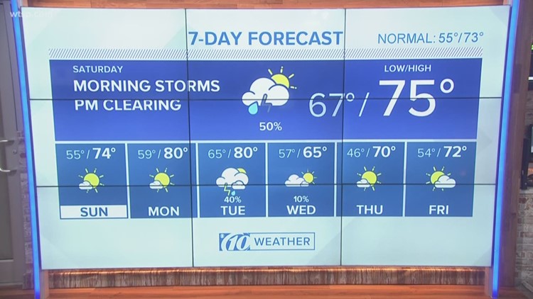
Otherwise, temperatures this afternoon will warm into the low 70s, but it'll feel a little cooler because of breezy conditions. The winds will pick up to 10-15 mph with gusts up to 20 mph.
5:15 am Saturday
The earlier tornado warning has expired. However, we are still watching another round of storms that will bring along a threat for some strong, if not severe storms.
A line of strong storms moving through the Nature Coast, extending back into the Gulf of Mexico, is moving east. Embedded storms within this line may produce some severe weather. A severe thunderstorm watch is in effect for all of Tampa Bay until 11 am.
The primary threat for severe weather will be damaging, straight-line winds, but an isolated tornado cannot be ruled out.
4:45 am Saturday
A tornado warning has been issued for Hernando and Citrus Counties until 5:15 am. If you are in the path of the storm you need to seek shelter now.
Earlier:
It will be important to stay weather aware early Saturday morning.
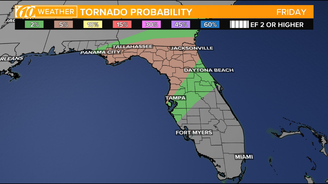
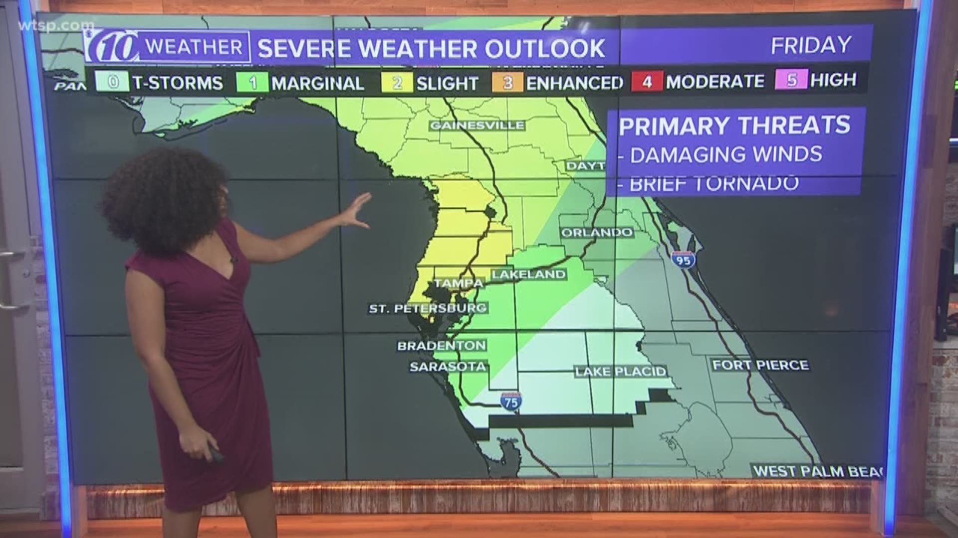
The Storm Prediction Center has Tampa Bay and areas north lying in a "slight risk" for severe weather Friday into Saturday morning.
A line of storms ahead of a cold front moving in late Friday into Saturday morning has the potential to be severe with straight line winds as the primary concern.

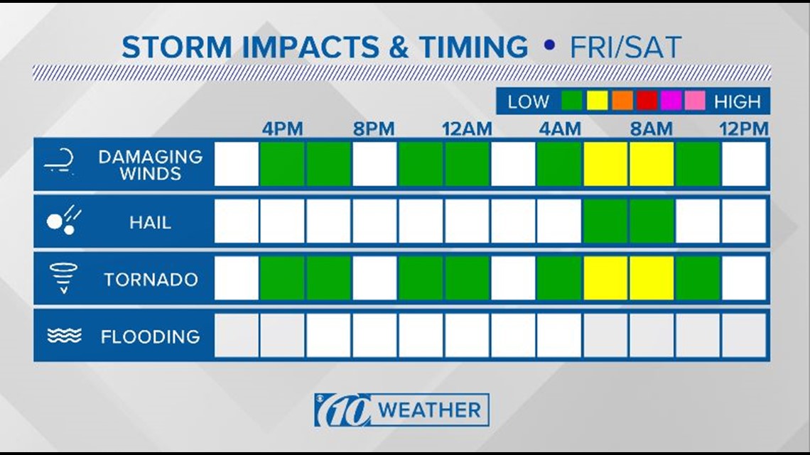
Although strong winds are the main threat, an isolated tornado can not be ruled out.
It is important to note that while the threat for a tornado is low during this weather event, Florida averages two tornadoes in the month of December.

Timing for this round of potentially strong storms looks to be between 3 and 6 a.m. This window will likely change, as these storms could arrive a bit earlier.
According to the National Weather Service, here are a few severe weather tips to keep in mind throughout the night:
- GET IN - If you are outside, get inside. If you're already inside, get as far into the middle of the building as possible.
- GET DOWN - Get underground if possible. If you cannot, go to the lowest floor possible.
- COVER UP - Flying and falling debris are a storm's number one killer. Use pillows, blankets, coats, helmets, etc to cover up and protect your head and body from flying debris.
What other people are reading right now:
- Baby born at 12:12 a.m. on 12/12 in Illinois
- Florida missing child alert: Have you seen baby Bella?
- A second ancient gold coin found in Salvation Army Red Kettle in Tampa
- A horse was killed. Florida investigators say it's becoming a terrible trend
- Detectives: More than $16 million in jewelry stolen in store burglaries around Florida
- Here's how you can participate in the #10News12Days Photo Challenge
FREE 10NEWS APP: