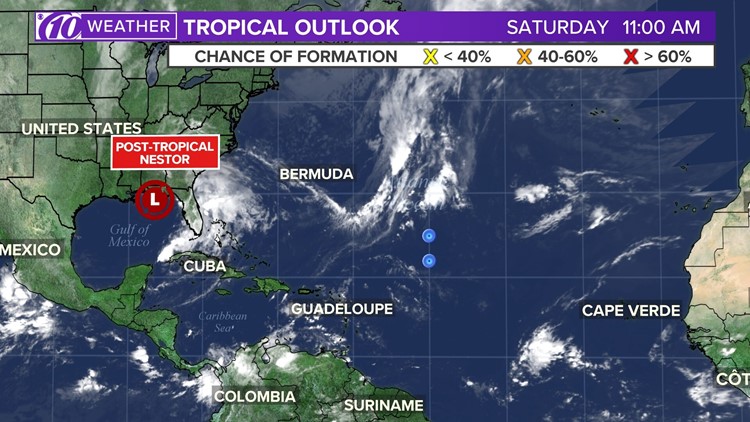
Nestor has lost its tropical characteristics and becomes a low post-tropical low-pressure system.
Strong gusty winds and storm surge are still affecting the coast of the Florida Panhandle.
PREVIOUS STORY
Tropical Storm Nestor is weakening as it gets closer to making landfall along the Florida Gulf Coast.
A storm surge warning and a tropical storm warning are in effect for coastal Levy County. A storm surge warning is also in effect for coastal Citrus, Hernando, Pasco and Pinellas counties. A coastal flood advisory has been issued for coastal Hillsborough and Manatee counties.
The National Hurricane Center said dangerous storm surge and tropical storm-force winds are expected later tonight and into Saturday.
Nestor is about 85 miles south-southwest of Panama City, Florida, according to the latest NHC advisory. It has maximum sustained winds of 50 mph and is moving northeast at 17 mph.
The NHC said tropical storm conditions are expected to reach the Gulf coast within the warning area later Friday. Gale-force winds are likely along parts of the Atlantic coast of the southeastern U.S. by Saturday.
Nestor is forecast to bring 1-3 inches of rain across Tampa Bay tonight through Sunday. An estimated 2-4 inches of rain will be possible near the storm center from the central Gulf Coast and northern and central Florida to the eastern Carolinas.
Warnings and watches in effect:
Tropical storm warning: Navarre to Yankeetown, Florida.
What's it mean? A tropical storm warning means that winds of (39 to 73 mph) associated with a tropical cyclone are expected within 36 hours or less.
Storm surge warning: Indian Pass, Florida to Clearwater Beach, Florida.
What's it mean? A storm surge warning is defined as the danger of life-threatening inundation from rising water moving inland from the shoreline, generally within 36 hours, in association with a tropical, subtropical, or post-tropical cyclone.
Coastal Flood Advisory: Coastal Hillsborough and Manatee counties. Areas of coastal flooding will be possible through Sunday morning, especially during high tides. Check the high tide times for your area.
What's it mean? A coastal flood advisory indicates that onshore winds and tides will combine to generate flooding of low areas along the shore.
High surf advisory: A High surf advisory remains in effect from 1 am Saturday until 8 am Sunday for most Tampa Bay Area beaches for an expected high surf or waves of 5 to 7 feet.
What's it mean? A High Surf Advisory means that high surf will affect beaches in the advisory area, producing localized beach erosion and dangerous swimming conditions.
Other concerns: There is also a high rip current risk for Tampa Bay waters through Sunday evening. Wind-driven surf and increasing wave action will create dangerous rip currents. These strong rip currents will create dangerous swimming conditions at area beaches.
What other people are reading right now:
- Florida man forced to pay child support despite DNA test showing he's not the father
- New York man sues NBC Universal over 'unlimited' refills theme park cup
- Storm surge warning in effect ahead of Potential Tropical Cyclone 16
- Help find the person who lost a wedding ring at St. Pete Beach
- Coroner: Ohio baby found in well was placed in plastic bags, crates bound by chains
- Man accused of molesting children at Disney World
FREE 10NEWS APP: